“We’re a geo-intelligence company. It sounds fancy, but what does that mean? Well, we make maps, but it’s really a lot more advanced than that.”
Indeed it is. Bernard Wright launched Geo Gecko in 2013 after working for nine years in the development and humanitarian sector.
“I got tired with the lack of innovation and making pretty, but non-decision-influencing, maps. So, I defected to the dark side of the private sector,” he told Disrupt Africa.
Geo Gecko aims to solve real world challenges using tools such as Geographic Information Systems (GIS), satellite imagery, drones and cloud computing to provide evidence and insight in data-starved environments.
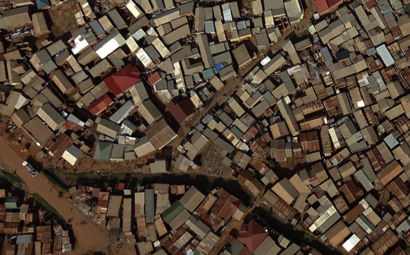
“We use satellites to monitor crop health, drones to assess flood risk in slums and sonar to map the base of lakes and rivers,” Wright said.
“We track poachers and the rangers chasing them in national parks. We fly drones over slums to identify flood prone areas. We use telecoms data to monitor movement of populations and finance. We use satellites to monitor the health of crops on three continents every week. A lot more than a map.”
The startup has acquired customers all over the world, which Wright attributes to the amount of valuable information it is unlocking for customers in a variety of sectors.
“The entire earth is recorded twice a day by satellites. These aren’t just pretty pictures. Data is locked in there ready to be released and analysed,” he said.
“We have a direct feed to the satellite companies and automatically pull images for our areas of interest to our server. There, our algorithms are automatically triggered. They generate information about each pixel in the image, like how much moisture is in the soil for a 3*3m square. This is then compared to the historical values so we can answer questions like, is it wetter now when compared with 6 months ago?”
Geo Gecko then makes this data available via its web maps and its data-as-a-service setup, so customers can integrate it into their own platforms.
“The agribusiness firm Olam uses our data to monitor their crops on three continents. We’re providing it to others who work with large networks of smallholder farmers. When it comes to smallholders the data is not perfect. If you show the results to a farmer with half an acre, he may not be impressed. But it is standardised, low-cost and frequently updated data which brewers and others with outgrower schemes need. We’re working on refining it further to identify harvest time, and how planting time correlates with rainfall,” Wright said.
“The frequency and resolution of satellite imagery is improving every day, as is machine learning to interpret it. The cost is dropping too. We’re building tools to simplify accessing this powerful intelligence for those who truly need it.”
He launched Geo Gecko in Uganda because “there are massive, economy changing things happening here”, yet big decisions are being made based on poor quality data, or none at all.
“We generate information, so decision-makers can act based on evidence. We use the only two sources of big data on the continent – daily satellite imagery and telecoms call data records,” Wright said.
Geo Gecko has been self-funded thus far, but is speaking to investors now it has a package of products and is ready to scale to new territories.
“We have a physical presence in Uganda and are planning to expand that to another country in East and Southern Africa soon. We’ll be keeping our HQ here in Kampala as it’s a great place to work and the talent pool is very decent,” Wright said.
“We’re not constrained by our physical location though. The beauty of using satellites as a source of data means that we can zoom in to anywhere on the globe and quantify what’s happening on the ground. I can tell you how much moisture is in the soil for a field in Brazil last week and how that compares with last year. We’re doing that now for large scale agribusinesses and people acquiring land.”
Geo Gecko has a very varied client base.
“Around 50 per cent of our clients are private and 50 per cent are humanitarian, development, or government actors. International agribusiness firms, government, city authorities, commercial farmers and engineering firms. Never boring. We’re always learning something new like how the fall armyworm moves in order to track it via satellite,” he said.


